Hurricane Polo Breaks the Scale?
Polo reached extraordinary Category 5 intensity and repeatedly rebuilt its eye. But does a T-number of 8.0 really mean a Category 7 hurricane?
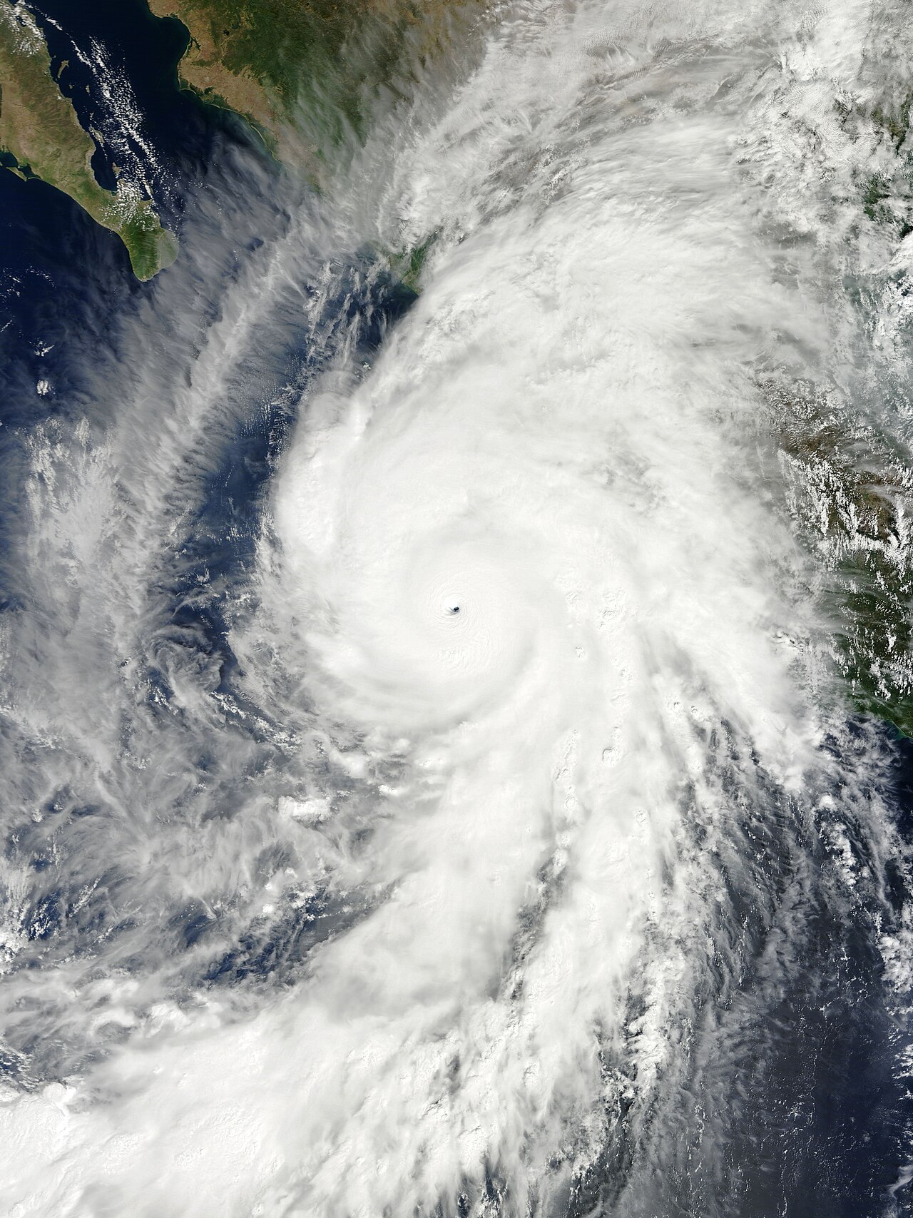
Hurricane Polo has become the kind of storm that makes familiar weather language feel inadequate. It reached Category 5 strength, weakened, rebuilt its core and returned to the top of the Saffir–Simpson scale more than once. At one stage, the U.S. National Hurricane Center estimated sustained winds near 180 to 185 mph and pressure around 892 millibars—more extreme than several figures circulating online.
That does not make Polo a “Category 7” hurricane.
The official Saffir–Simpson Hurricane Wind Scale has five categories. Category 5 begins at 157 mph and has no upper limit. A storm with 160 mph winds and one with 185 mph winds therefore receive the same category even though their destructive potential is not identical.
The viral T8.0 claim refers to something different: the Dvorak technique, which estimates tropical-cyclone intensity from satellite appearance. Its T-numbers are not hurricane categories. Available National Hurricane Center discussions cited a T7.5 classification during one of Polo’s peaks. Analysts may publish higher real-time estimates, but those remain intensity estimates—not a new category on the public warning scale.
Polo’s satellite structure explains the fascination. A powerful, symmetric eyewall produced the “stadium effect,” in which the eye widens upward like a stadium bowl. The storm also underwent eyewall replacement cycles: the inner eyewall weakened while a larger outer ring contracted, allowing the hurricane to reorganize and intensify again.
Calling this a triple Category 5 peak may be descriptively reasonable if the post-season record confirms three separate periods above the threshold. Real-time intensity histories are often revised after aircraft, satellite and surface observations are reanalyzed.
Did climate change create Polo?
No single hurricane can be attributed to one cause in the simple sense that a match causes a fire. Hurricanes require warm water, moisture, atmospheric instability and favorable winds. El Niño can rearrange those ingredients, strengthening activity in the eastern Pacific while suppressing parts of the Atlantic through increased wind shear.
The World Meteorological Organization says the current El Niño is expected to become very strong. Exceptionally warm Pacific water provides more energy and moisture for storms that find favorable atmospheric conditions.
Human-driven warming adds another layer. Warmer oceans and air can increase potential intensity and rainfall, while rising seas make storm surge more damaging. Scientists are more confident about increasing rainfall and extreme intensity potential than about a simple rise in the total number of hurricanes everywhere.
That distinction matters. “Climate-fueled” should mean that warming changed the environment in which Polo developed—not that climate change invented the storm or that every feature has one explanation.
Should the scale add Category 6?
Researchers have debated adding a category above 5 because the strongest modern storms can sit far beyond the existing threshold. Supporters say a new label could communicate exceptional wind risk. Critics warn it would intensify fixation on wind while rainfall, flooding, storm surge and size often kill more people.
The National Hurricane Center emphasizes individual hazards rather than expanding the scale. A weakening Category 4 approaching land can be more dangerous than a compact Category 5 staying offshore.
Polo’s core was forecast to remain offshore from southwestern Mexico, but its rain bands still threatened flash floods, landslides, dangerous surf and rip currents. A spectacular eye over open water does not eliminate risk on land.
The most honest headline is therefore less futuristic and more serious: Polo is an extraordinary Category 5 hurricane within an unusually warm Pacific system. It does not need an invented category to be alarming.
Forecast communication should also separate intensity from impact. Aircraft measurements can change the official wind estimate within hours, while a small shift in track can transform rainfall and surf risk. The strongest number is not always the most useful one for residents deciding whether to evacuate. Local civil-protection instructions, flood maps and road conditions should take priority over dramatic satellite terminology shared globally.
What to watch next
- Whether post-season analysis confirms Polo’s peak winds, pressure and number of Category 5 cycles.
- Rainfall, flooding and landslide impacts along Mexico’s Pacific coast.
- Whether eyewall replacement causes another strengthening phase or steady weakening.
- Updated WMO assessments of the 2026–27 El Niño.
- The scientific debate over whether public warning scales should extend beyond Category 5.
Is “Category 7” useful shorthand for unprecedented danger, or does it confuse two different measurement systems at the moment accurate communication matters most?